15.42.020 Definitions.
For purposes of this chapter, the following definitions shall apply:
“Arterial” means a road or street primarily for through traffic. A major arterial connects an interstate highway to cities and counties. A minor arterial connects major arterials to collectors. A collector connects an arterial to a neighborhood. A collector is not an arterial. A local access road connects individual homes to a collector.
“Best management practices (BMPs)” means schedules of activities, prohibitions of practices, maintenance procedures, and other physical, structural, and/or managerial practices that prevent or reduce the release of pollutants and other adverse impacts to waters of Washington State. BMPs can be used singularly or in combination. BMPs have been approved by Ecology. BMPs are listed and described in the Ecology Manual, current edition.
A. “Source control BMP” means a BMP that is intended to prevent pollution from entering stormwater.
B. “Treatment BMP” means facilities that remove pollutants by simple gravity settling of particulate pollutants, centrifugal separation, filtration, biological uptake, and media or soil adsorption.
C. “Flow control BMP” means BMPs that control the volume rate, frequency, and flow duration of stormwater surface runoff.
D. “Low impact development BMP” means a set of BMPs containing treatment and flow control solutions that are contained in the LID Guidance Manual.
E. “Experimental BMP” means any treatment or methodology proposed for treatment or management of stormwater that is not in the Ecology Manual (current edition) and is being studied by the city, Whatcom County and/or the Washington State Department of Ecology for adoption as a BMP.
“Bioretention” means an integrated stormwater management practice that uses the chemical, biological, and physical property of plants, microbes, and soils to remove or retain pollutants from stormwater runoff. Bioretention facilities are depressions that can be isolated detention cells, swales for conveyance as well as treatment, or a connected-cell hybrid of the two. Bioretention facilities include compost amended soils, landscape plantings selected for tolerance to a range of conditions and a mulch layer.
“Clearing” means the destruction and removal of vegetation by manual, mechanical, chemical or other such method.
“Critical areas” means those areas defined in Chapter 16.55 BMC.
“Critical basins” means those geographic basin areas that are of exceptional significance and that have been determined by the city to require special protection. The Lake Whatcom watershed has been determined to be a critical basin.
“Detention” means the release of stormwater runoff from the site at a slower rate than it is collected by the stormwater facility system, the difference being held in temporary storage.
“Detention facility” means an above or below ground facility, such as a pond or tank, that temporarily stores stormwater runoff and subsequently releases it at a slower rate than it is collected by the drainage facility system. There is little or no infiltration of stored stormwater.
“Development” means new development, redevelopment, or both, including a combination thereof. See definitions for each.
“Director” means the director of the public works department or his/her assignee.
“Drainage basin” means a geographic and hydrologic subunit of a watershed.
“Ecology” or “DOE” means the Washington State Department of Ecology.
“Ecology Manual” means the Washington State Department of Ecology “Stormwater Management Manual for Western Washington” as currently adopted or hereafter modified. The LID Guidance Manual shall be considered a portion of this manual.
“Effective impervious surface” means those impervious surfaces that are connected via sheet flow or discrete conveyance to a drainage system. Impervious surfaces are considered ineffective if: (1) the runoff is dispersed through at least 100 feet of native vegetation in accordance with BMP T5.30 – “Full Dispersion” as described in Chapter 5 of Volume V of the Ecology Manual; (2) residential roof runoff is infiltrated in accordance with downspout full infiltration systems in BMP T5.10A in Volume III of the Stormwater Management Manual; or (3) approved continuous runoff modeling methods indicate that the entire runoff is infiltrated.
“Erosion” means the wearing away of the land surface by running water, wind, ice, or other geological agents, including such processes as gravitational creep. Also, detachment and movement of soil or rock fragments by water, wind, ice, or gravity.
“Excavation” means the mechanical removal of earth material.
“Feasible” means the design criteria, limitations, and infeasibility criteria for each LID BMP as described in the Ecology Manual.
“Fill” means a deposit of earth material placed by artificial means.
“Forest practice” means any activity conducted on or directly pertaining to forest land and relating to growing, harvesting, or processing timber, including but not limited to:
A. Road and trail construction;
B. Harvesting, final and intermediate;
C. Precommercial thinning;
D. Reforestation;
E. Fertilization;
F. Prevention and suppression of diseases and insects;
G. Salvage of trees; or
H. Brush control.
“Hard surface” means an impervious surface, a permeable pavement, or a vegetated roof.
“Highway” means a main public road connecting towns and cities.
“Hydroperiod” means a seasonal occurrence of flooding and/or soil saturation; it encompasses depth, frequency, duration, and seasonal pattern of inundation.
“Illicit discharge” means all nonstormwater discharges to natural or manmade stormwater drainage systems, including but not limited to sanitary sewer connections, industrial process water, interior floor drains, car washing, and greywater systems. All nonstormwater discharges not listed below are considered to be an illicit discharge.
A. The following are allowed discharges:
1. Diverted stream flows.
2. Rising ground waters.
3. Uncontaminated ground water infiltration (as defined in 40 CFR 35.2005(20)).
4. Uncontaminated pumped ground water.
5. Fountain drains.
6. Air conditioning condensate.
7. Irrigation water from agricultural sources that is commingled with urban stormwater.
8. Springs.
9. Water from crawl space pumps.
10. Footing drains.
11. Flows from riparian habitats and wetlands.
12. Nonstormwater discharges covered by and compliant with another NPDES permit.
13. Discharges from emergency firefighting activities in accordance with permit condition S2 of the Western Washington Phase II Municipal Stormwater Permit Authorized Discharges.
B. The following are conditionally allowed discharges:
1. Discharges from potable water sources, including water line flushing, hyperchlorinated water line flushing, fire hydrant system flushing, and pipeline hydrostatic test water. Planned discharges will be to sanitary sewer. If sanitary sewer is not an option, the water shall be dechlorinated to a concentration of 0.1 ppm or less, pH-adjusted, if necessary, and volumetrically and velocity controlled to prevent resuspension of sediments in the stormwater drainage system.
2. Dechlorinated swimming pool discharges. Any swimming pool, spa, or hot tub discharge that may be allowed must be dechlorinated to a concentration of 0.1 ppm or less, thermally controlled, pH-adjusted and reoxygenized. Discharge volume and velocity will be controlled to prevent scour or resuspension of sediments in city stormwater conveyances. Swimming pool, spa or hot tub cleaning water and filter backwash is not an allowed discharge.
3. Street and sidewalk wash water, water used to control dust, and routine external building wash down are allowed if the water does not contain detergents and/or particulates will not cause an exceedance of state water quality standards. For city operations, to the extent practicable, the amount of street wash and dust control water used shall be minimized. At active construction sites, BMC 15.42.060(F)(2)(e)(ii)(D) requires that street sweeping must be performed prior to the washing of any street.
4. Stormwater discharges associated with construction, including dewatering practices, are regulated and enforced per this chapter.
“Impervious surface” means a nonvegetated surface that either prevents or retards the entry of water into the soil mantle as under natural conditions prior to development. A nonvegetated surface area which causes water to run off the surface in greater quantities or at an increased rate of flow from the flow present under natural conditions prior to development. Common impervious surfaces include, but are not limited to, rooftops, walkways, patios, driveways, parking lots or storage areas, concrete or asphalt paving, packed gravel surfaces, packed earthen materials, and oiled, macadam or other surfaces which similarly impede the natural infiltration of stormwater. Open, uncovered retention/detention facilities shall not be considered as impervious surfaces for purposes of determining whether the thresholds for application of minimum requirements are exceeded. Open, uncovered retention/detention facilities shall be considered impervious surfaces for purposes of runoff modeling. Impervious surfaces that meet the criteria for full dispersion or that are fully infiltrated in compliance with the Ecology Manual shall be excluded in the determination of thresholds for compliance with this chapter.
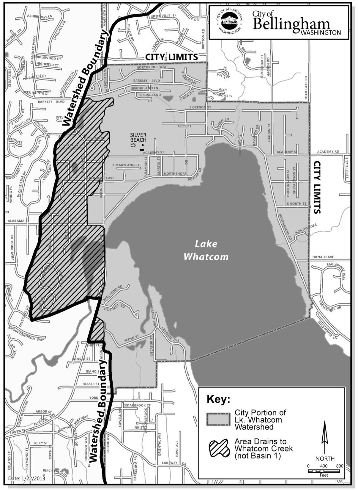
“Lake Whatcom watershed” means all those lands that drain into Lake Whatcom. The terminus of the Lake Whatcom watershed is the city of Bellingham control dam located at the juncture of Lake Whatcom and Whatcom Creek. The boundaries are shown on Map 15.42.020. Where in conflict, the definition of the watershed boundaries provided herein shall supersede the map.
“Lake Whatcom watershed Basin One” means those lands within the Lake Whatcom watershed that drain into Basin One of Lake Whatcom via natural topography or through manmade conveyance systems. The boundaries of Basin One are shown on Map 15.42.020. Where in conflict, the definition of the watershed boundaries provided herein shall supersede the map.
“Land-disturbing activity” means any activity that results in movement of earth, or a change in the existing soil cover (both vegetative and nonvegetative) and/or the existing soil topography. Land-disturbing activities include, but are not limited to, clearing, grading, filling, and excavation. Compaction that is associated with stabilization of structures and road construction shall also be considered a land-disturbing activity. Vegetation maintenance practices or gardening are not generally considered land-disturbing activity. Stormwater facility maintenance is not considered land-disturbing activity if conducted according to established standards and procedures. The exception is that within Basin One of the Lake Whatcom watershed such activities are limited to the provisions for exempt gardens within this code.
“LID Guidance Manual” means the current edition of the Low Impact Development Technical Guidance Manual for Puget Sound, prepared by the Puget Sound Partnership and the Washington State University Pierce County Extension.
“Low impact development (LID)” means a group of BMPs and land use practices that are aimed at lessening the hydrologic and water quality impacts to the environment from development. LID practices include, but are not limited to, reduction in impervious surfaces, infiltration of flow, dispersion of flow, soil remediation and cluster development.
Maintenance. “Repair and maintenance” includes activities conducted on currently serviceable structures, facilities, and equipment that involve no expansion or use beyond that previously existing use and result in no significant adverse hydrologic impact. It includes those usual activities taken to prevent a decline, lapse, or cessation in the use of structures and systems. Those usual activities may include removal and replacement of disfunctioning facilities, including cases where environmental permits require replacing an existing structure with a different type structure, as long as the functioning characteristics of the original structure are not changed. By way of example is the replacement of a collapsed, fish blocking, round culvert with a new box culvert under the same span, or width, of roadway.
“Master plan” means the city of Bellingham’s watershed master plan or stormwater comprehensive plan.
“Mitigation” means, in the following order of preference:
A. Avoiding the impact altogether by not taking a certain action or part of an action;
B. Minimizing impacts by limiting the degree or magnitude of the action and its implementation, by using appropriate technology, or by taking affirmative steps to avoid or reduce impacts;
C. Rectifying the impact by repairing, rehabilitating or restoring the affected environment;
D. Reducing or eliminating the impact over time by preservation and maintenance operations during the life of the action; and
E. Compensating for the impact by replacing, enhancing, or providing substitute resources or environments.
“Native vegetation” means vegetation comprised of plant species, other than noxious weeds, that are indigenous to the coastal region of the Pacific Northwest and which reasonably could have been expected to naturally occur on the site. Examples include trees such as Douglas fir, western hemlock, western red cedar, alder, big-leaf maple, and vine maple; shrubs such as willow, elderberry, salmonberry, and salal; and herbaceous plants such as sword fern, foam flower, and fireweed.
“Natural forested condition” means a vegetated condition mimicking well-established forests and supporting soils found in the lowlands of Whatcom County prior to European settlement. The pre-European-settlement condition is characterized by an extensive canopy cover dominated by native coniferous trees, a significant duff layer, and all distinct plant layers present (tree, shrub, and ground cover). The natural forested condition shall function and perform as the “forested condition” in the Department of Ecology Stormwater Manual, current edition.
“Natural location” means the location of those channels, swales, and other nonmanmade conveyance systems as defined by the first documented topographic contours existing for the subject property, either from maps or photographs, or such other means as appropriate. In the case of outwash soils with relatively flat terrain, no natural location of surface discharge may exist.
“New development” means land-disturbing activities, including Class IV general forest practices that are conversions from timber land to other uses; structural development, including construction or installation of a building or other structure; creation of impervious surfaces; and subdivision, short subdivision and binding site plans, as defined and applied in Chapter 58.17 RCW. Projects meeting the definition of redevelopment shall not be considered new development.
“New impervious surface” means impervious surfaces that replace or supplant existing pervious surfaces. For road construction projects, extending the pavement edge without increasing the size of the road prism, or paving graveled shoulders, resurfacing by upgrading from dirt to gravel, asphalt, or concrete; upgrading from gravel to asphalt, or concrete; or upgrading from a bituminous surface treatment (“chip seal”) to asphalt or concrete: These are considered new impervious surfaces and are subject to the minimum requirements that are triggered when the thresholds identified for development or redevelopment projects are met. For other development, the replacement of compacted dirt, gravel or bituminous surface treatment, regardless of use, with structural development, asphalt or concrete shall constitute a new impervious surface.
“Partially pervious surface” means surfaces that cause an increase in stormwater runoff from a natural forested condition but that are not clearly a defined impervious surface. Common surfaces in this category are lawns, landscaping areas, gardens, areas that have been cleared of native vegetation, and nonengineered pervious driveways that have not been proven through engineering analysis as being capable of fully infiltrating the water from a 100-year developed condition storm. (Applies to Basin One of Lake Whatcom watershed only.)
“Permeable pavement” means pervious concrete, porous asphalt, permeable pavers or other forms of pervious or porous paving material intended to allow passage of water through the pavement section. It often includes an aggregate base that provides structural support and acts as a stormwater reservoir.
“Person” means any individual, partnership, corporation, association, organization, cooperative, public or municipal corporation, agency of the state, or local government unit, however designated.
“Pervious surface” means any surface material that allows stormwater to infiltrate into the ground. Examples include lawn, landscape, pasture, native vegetation, and permeable pavements.
“Pollution” means contamination or other alteration of the physical, chemical, or biological properties of waters of the state, including change in temperature, taste, color, turbidity, or odor of the waters, or such discharge of any liquid, gaseous, solid, radioactive or other substance into any waters of the state as will or is likely to create a nuisance or render such waters harmful, detrimental or injurious to the public health, safety or welfare, or to domestic, commercial, industrial, agricultural, recreational, or other legitimate beneficial uses, or to livestock, wild animals, birds, fish or other aquatic life.
“Pollution-generating hard surface (PGHS)” means those hard surfaces considered to be a significant source of pollutants in stormwater runoff. Such surfaces include those which are subject to: vehicular use; industrial activities (as defined in the Ecology Manual); or storage of erodible or leachable materials, wastes, or chemicals, and which receive direct rainfall or the run-on or blow-in of rainfall. Erodible or leachable materials, wastes, or chemicals are those substances which, when exposed to rainfall, measurably alter the physical or chemical characteristics of the rainfall runoff. Examples include erodible soils that are stockpiled, uncovered process wastes, manure, fertilizers, oily substances, ashes, kiln dust, and garbage dumpster leakage. Metal roofs are also considered to be PGHS unless they are coated with an inert, nonleachable material (e.g., baked-on enamel coating). A surface, whether paved or not, shall be considered subject to vehicular use if it is regularly used by motor vehicles. The following are considered regularly used vehicular surfaces: roads, unvegetated road shoulders, bike lanes within the traveled lane of a roadway, driveways, parking lots, unfenced fire lanes, vehicular equipment storage yards, and airport runways. The following are not considered regularly used vehicular surfaces: paved bicycle pathways separated from and not subject to drainage from roads for motor vehicles, fenced fire lanes, and infrequently used maintenance access roads.
“Pollution-generating impervious surface (PGIS)” means those impervious surfaces considered to be a significant source of pollutants in stormwater runoff. Such surfaces include those which are subject to: vehicular use; industrial activities (as defined in the Ecology Manual); or storage of erodible or leachable materials, wastes, or chemicals, and which receive direct rainfall or the run-on or blow-in of rainfall. Erodible or leachable materials, wastes, or chemicals are those substances which, when exposed to rainfall, measurably alter the physical or chemical characteristics of the rainfall runoff. Examples include erodible soils that are stockpiled, uncovered process wastes, manure, fertilizers, oily substances, ashes, kiln dust, and garbage dumpster leakage. Metal roofs are also considered to be PGIS unless they are coated with an inert, nonleachable material (e.g., baked-on enamel coating). A surface, whether paved or not, shall be considered subject to vehicular use if it is regularly used by motor vehicles. The following are considered regularly used surfaces: roads, unvegetated road shoulders, bike lanes within the traveled lane of a roadway, driveways, parking lots, unfenced fire lanes, vehicular equipment storage yards, and airport runways. The following are not considered regularly used surfaces: paved bicycle pathways separated from and not subject to drainage from roads for motor vehicles, fenced fire lanes, and infrequently used maintenance access roads.
“Pollution-generating pervious surfaces (PGPS)” means any nonimpervious surface subject to vehicular use, industrial activities; or the storage of erodible or leachable materials, wastes, or chemicals, and that receive direct rainfall or run-on or blow-in of rainfall, the use of pesticides and fertilizers or loss of soil. Typical PGPS include, by way of example, permeable pavement subject to vehicular use, lawns, landscaped areas, golf courses, parks, cemeteries, and sports fields (natural and artificial turf).
Predeveloped Condition. For areas that drain directly or indirectly to a river or stream, “predeveloped conditions” shall mean the native vegetation and soils that existed at a site prior to the influence of Euro-American settlement. The predeveloped condition shall be assumed to be a forested land cover unless reasonable, historic information is provided that indicates the site was prairie prior to settlement.
“Project site” means that portion of a property, properties, or right-of-way subject to land-disturbing activities, new hard surfaces, or replaced hard surfaces. The total projected area of new, replaced or new plus replaced hard surfaces for subdivisions shall constitute a project site. Project site shall also include any and all areas of the project property or properties that have been previously developed on or after September 1, 1995, if said development did not provide permanent stormwater facilities for water quality and quantity mitigation.
“Receiving waters” means bodies of water or surface water systems to which surface runoff is discharged via a point source of stormwater or via sheet flow.
“Redevelopment” means, on a site that is already substantially developed (which means 35 percent or more of existing impervious surface coverage, 10 percent or more for Basin One of Lake Whatcom watershed), the creation or addition of impervious surfaces; the expansion of a building footprint or addition or replacement of a structure; structural development including construction, installation or expansion of a building or other structure; replacement of impervious surface that is not part of a routine maintenance activity; and land-disturbing activities. For Basin One of the Lake Whatcom watershed redevelopment also means the creation of or expansion of partial pervious surfaces.
“Regional retention/detention system” means a stormwater quantity control structure designed to correct existing surface water runoff problems of a basin or sub-basin. The area downstream has been previously identified as having existing or predicted significant and regional flooding and/or erosion problems. This term is also used when a detention facility is sited to detain stormwater runoff from a number of new developments or areas within a catchment.
“Replaced hard surface” means, for structures, the removal and replacement of hard surfaces down to the foundation. For other hard surfaces, the removal down to bare soil or base course and replacement. The pulverization and replacement of like pavement is considered a replaced hard surface. The partial grinding of surfaces for overlay is considered to be a maintenance activity.
“Replaced impervious surface” means, for structures, the removal and replacement of impervious surfaces down to the foundation. For other impervious surfaces, the removal down to bare soil or base course and replacement. The pulverization and replacement of like pavement is considered a replaced impervious surface. The partial grinding of surfaces for overlay is considered to be a maintenance activity.
“Site” means the area defined by the legal boundaries of a parcel or parcels of land that is (are) subject to new development or redevelopment. For road projects, the length of the project site and the right-of-way boundaries define the site.
“Soil” means the unconsolidated mineral and organic material on the immediate surface of the earth that serves as a natural medium for the growth of land plants.
“Source control BMP” means a structure or operation that is intended to prevent pollutants from coming into contact with stormwater through physical separation of areas or careful management of activities that are sources of pollutants. This manual separates source control BMPs into two types. Structural source control BMPs are physical, structural, or mechanical devices, or facilities that are intended to prevent pollutants from entering stormwater. Operational BMPs are nonstructural practices that prevent or reduce pollutants from entering stormwater. See Ecology Manual, Volume IV for details.
“Stormwater” means that portion of precipitation that does not naturally percolate into the ground or evaporate, but flows via overland flow, interflow, pipes and other features of a stormwater drainage system into a defined surface water body, or a constructed infiltration facility.
“Stormwater drainage system” means constructed and natural features which function together as a system to collect, convey, channel, hold, inhibit, retain, detain, infiltrate, divert, treat or filter stormwater.
“Stormwater facility” means a constructed component of a stormwater drainage system designed or constructed to perform a particular function, or multiple functions. Stormwater facilities include, but are not limited to, pipes, swales, ditches, culverts, street gutters, detention ponds, retention ponds, constructed wetlands, infiltration devices, catch basins, oil/water separators, and biofiltration swales.
Stormwater Management Manual for Western Washington (Stormwater Manual). This manual, as prepared by and updated by the Department of Ecology, contains BMPs to prevent, control or treat pollution in stormwater and reduce other stormwater-related impacts to waters of the state and shall be interpreted to mean the current edition. The stormwater manual is intended to provide a supplement to this BMC to control the quantity and quality of stormwater runoff from new development and redevelopment. The stormwater manual shall be used for the guidance of designs, reports and construction for all development and redevelopment within the city of Bellingham except where this chapter provides for more specific direction regarding stormwater management.
“Stormwater site plan” means the comprehensive report containing all of the technical information and analysis necessary for the city of Bellingham and other regulatory agencies to evaluate a proposed new development or redevelopment project for compliance with stormwater requirements. Contents of the stormwater site plan will vary with the type and size of the project, and individual site characteristics. It includes a construction stormwater pollution prevention plan (“construction SWPPP”) and a permanent stormwater control plan (“PSC plan”). The stormwater site plan shall be prepared in accordance with the Ecology Manual and/or other city of Bellingham guidance documents including this code.
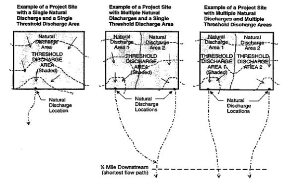
“Threshold discharge area” means an on-site area draining to a single natural discharge location or multiple natural discharge locations that combine within one-quarter mile downstream (as determined by the shortest flow path). The examples in Figure 15.42.020 illustrate this definition. The purpose of this definition is to clarify how the thresholds of the DOE Manual are applied to project sites with multiple discharge points.
Figure 15.42.020
“Vegetation” means all organic plant life growing on the surface of the earth.
“Water body” means surface waters including rivers, streams, lakes, marine waters, estuaries, and wetlands.
“Watershed master plan,” “the plan” or “the stormwater comprehensive plan” means documents created for the comprehensive management of stormwater for the city of Bellingham urban areas and suburban fringe areas and are adopted by reference. The documents include the current editions of Volume I and II of the 1995 Watershed Master Plan, the Stormwater Management Handbook, the 2007 Stormwater Comprehensive Plan and all future updates to these documents.
“Wetlands” means those areas that are inundated or saturated by surface or ground water at a frequency and duration sufficient to support, and that under normal circumstances do support, a prevalence of vegetation typically adapted for life in saturated soil conditions. Wetlands generally include swamps, marshes, bogs, and similar areas. Wetlands do not include those artificial wetlands intentionally created from nonwetland sites, including, but not limited to, irrigation and drainage ditches, grass-lined swales, canals, detention facilities, wastewater treatment facilities, farm ponds, and landscape amenities, or those wetlands created after July 1, 1990, that were unintentionally created as a result of the construction of a road, street, or highway. Wetlands may include those artificial wetlands intentionally created from nonwetland areas to mitigate the conversion of wetlands. (Water bodies not included in the definition of wetlands as well as those mentioned in the definition are still waters of the state.)
Map 15.42.020
[Ord. 2017-03-009 § 4; Ord. 2009-06-041; Ord. 2006-05-047].